7-Day Rwenzori Central Circuit Trek with Margherita Peak (5,109meters)
Theme: High-Altitude Alpine Expedition | Glacier Summit
Route: Central Circuit via Nyakalengija
Highest Point: Margherita Peak – Mount Stanley (5,109m)
Safari Overview
This 7-day Rwenzori expedition follows the classic Central Circuit route culminating in the ascent of Margherita Peak, the highest point in Uganda and the third highest in Africa. The trek traverses all vegetation zones of the Rwenzori Mountains — from montane rainforest and bamboo forest to alpine bogs, glaciers, and permanent ice.
This itinerary is physically demanding and involves glacier travel, basic ice climbing techniques, and high-altitude exposure. Proper acclimatization and good fitness are essential.
What’s Included
-
Uganda Wildlife Authority (UWA) park entrance fees (USD 35 per person per day)
-
Professional mountain guides
-
Porters
-
Cook and full-board meals while on the mountain
-
Mountain hut accommodation during the trek
Note: Technical climbing gear (crampons, harness, ice axe, boots, etc.) can be hired separately prior to departure.
Detailed Day-by-Day Itinerary
Day 1: Nyakalengija (1,615m) → Nyabitaba Hut (2,651m)
Hiking Time: 6–7 hours
The trek begins at the Rwenzori Mountaineering Services headquarters in Nyakalengija. After registration, briefing, and final gear checks, the ascent starts through cultivated farmland before entering the park boundary. The trail follows the Mubuku River valley, crossing the Mahoma River, before beginning a sustained climb through dense montane forest. This section is rich in biodiversity. Expect sightings of black-and-white colobus monkeys, blue monkeys, and possibly hear chimpanzees in the distance. Birdlife is abundant, including the striking Rwenzori turaco. The day concludes at Nyabitaba Hut, perched on a ridge with sweeping views of the Mubuku Valley.
Day 2: Nyabitaba → John Matte Hut (3,505m)
Hiking Time: 7–8 hours
From Nyabitaba, descend through forest to the Kurt Shafer Bridge at the confluence of the Mubuku and Bujuku Rivers. The route transitions into bamboo forest before entering the heather zone. The terrain becomes progressively more challenging, including moss-covered rock sections and muddy stretches. As you gain elevation, dramatic views of Mount Stanley and Mount Speke emerge. The final approach crosses boggy ground before reaching John Matte Hut, located in the upper Bujuku Valley.
Day 3: John Matte Hut → Bujuku Hut (3,962m)
Hiking Time: 4–5 hours
Today’s trek crosses the Bujuku River into the Lower Bigo Bog — a surreal Afro-alpine landscape dominated by giant lobelias and groundsels. Movement requires careful footing across tussocks to avoid deep mud. The Upper Bigo Bog gradually opens toward Lake Bujuku, one of the most scenic alpine lakes in East Africa. The hut sits in a narrow valley beneath Mount Baker and Mount Speke, with Mount Stanley towering ahead. This shorter day supports acclimatization ahead of higher elevations.

Day 4: Bujuku → Elena Hut (4,541m)
Hiking Time: 5–6 hours
The ascent continues west of Lake Bujuku through steep slopes and dramatic alpine scenery. The trail climbs toward Groundsel Gully, where giant groundsels form an otherworldly forest. At a junction near Scott-Elliot Pass, trekkers attempting Margherita Peak turn toward Elena Hut, while others descend to Kitandara Lakes. The climb to Elena involves steep, rocky terrain requiring steady pacing. Elena Hut is basic and exposed, situated high on Mount Stanley’s flank. Early rest is essential for the summit attempt.
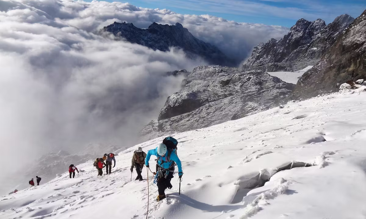
Day 5: Elena Hut → Margherita Peak (5,109m) → Kitandara Hut (4,430m)
Summit Time: 4–5 hours ascent | 2–3 hours descent to Elena
A pre-dawn start (around 2:00–3:00 AM) begins the summit push. Equipped with crampons, harnesses, and ice axes, climbers ascend onto the Stanley Plateau glaciers. The route crosses glacial ice, exposed rock sections, and steep snow slopes. Conditions vary depending on weather and glacier state. The final ascent to Margherita Peak requires steady effort but rewards climbers with panoramic views stretching into Congo and across the Rwenzori range. After summit photos, descend carefully back to Elena Hut for a short rest and meal. Continue downward via Scott-Elliot Pass into the Kitandara Lakes basin. Overnight at Kitandara Hut.
Day 6: Kitandara → Guy Yeoman Hut (3,261m)
Hiking Time: 6–7 hours
The trail climbs steeply from Kitandara toward Freshfield Pass (4,282m), offering expansive views of Mount Stanley and into the Democratic Republic of Congo. From the pass, descend through high alpine moss zones and rocky ridges. The route passes Bujongolo Rock Shelter, historically used by the Duke of Abruzzi’s expedition in 1906. Continue descending through rocky and moorland terrain to reach Guy Yeoman Hut.
Day 7: Guy Yeoman → Nyabitaba → Nyakalengija (1,615m)
Hiking Time: 7–8 hours
The final descent drops below Guy Yeoman through Kichuchu cliffs and bamboo forest. The trail reconnects with Nyabitaba Hut before continuing down the familiar forest path. Arrive at Nyakalengija in the afternoon, completing the full Central Circuit loop.
Trip Excludes
-
Technical climbing equipment hire
-
International flights
-
Uganda visa fees
-
Travel insurance (mandatory for high-altitude trekking)
-
Tips and gratuities
-
Personal hiking gear
-
Beverages and snacks outside standard meals

